Landslides are a major natural hazard that can have devastating consequences, particularly in mountainous regions like India’s Western Ghats. In this comprehensive study, researchers from the University of Florence explored the use of advanced machine learning (ML) algorithms and optimization techniques to assess landslide susceptibility in the Kerala region of the Western Ghats. By combining state-of-the-art ML models like Support Vector Regression (SVR) and Categorical Boosting (CatBoost) with population-based optimization algorithms like Particle Swarm Optimization (PSO) and Grey Wolf Optimizer (GWO), the researchers were able to develop highly accurate and reliable landslide susceptibility maps. This innovative approach not only outperformed traditional methods but also provided valuable insights into the key factors contributing to landslide risk in this critical region. The findings of this study have important implications for disaster risk management, urban planning, and climate change adaptation efforts in India and other parts of the world facing similar challenges. Landslides, Western Ghats, Machine Learning, Optimization Algorithms
Landslides in India’s Western Ghats: A Pressing Concern
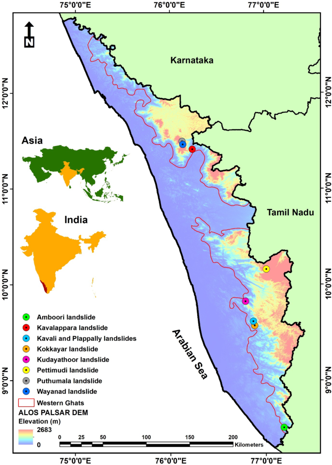
Landslides are a major natural hazard that can have devastating consequences, particularly in mountainous regions like India’s Western Ghats. This ecologically diverse and geologically complex mountain range, which runs parallel to the western coast of the Indian peninsula, is prone to frequent and often deadly landslide events. In recent years, the Western Ghats have experienced a surge in landslide incidents, with the state of Kerala being one of the worst-affected areas.
The 2018 Kerala Landslide Disaster is a prime example of the catastrophic impact of these events. During the heavy monsoon rains that year, over 4,700 landslides were reported in the region, leading to widespread destruction, loss of life, and disruption to critical infrastructure. This disaster highlighted the urgent need for more effective landslide risk assessment and management strategies in the Western Ghats.
Leveraging Machine Learning and Optimization Algorithms
In response to this pressing challenge, a team of researchers from the University of Florence conducted a comprehensive study to assess landslide susceptibility in the Kerala region of the Western Ghats. The researchers employed a novel approach that combined advanced machine learning (ML) algorithms with population-based optimization techniques to develop highly accurate and reliable landslide susceptibility maps.
The study began with the collection and analysis of a detailed landslide inventory, which included over 7,700 recorded landslide events in Kerala. The researchers then identified 18 potential predisposing factors, such as slope, elevation, soil characteristics, and land use, that could contribute to landslide risk in the region. These factors were carefully evaluated and reduced to a set of 14 key variables through a multi-stage feature selection process.
Next, the researchers implemented six different susceptibility models, combining two ML regression algorithms (SVR and CatBoost) with two optimization algorithms (PSO and GWO). The performance of these models was then rigorously evaluated using a range of validation metrics, including the Area Under the Receiver Operating Characteristic (ROC) Curve (AUC), Mean Absolute Error (MAE), Mean Squared Error (MSE), Root Mean Squared Error (RMSE), and Coefficient of Determination (R²).
Identifying the Most Influential Factors
The results of the study revealed that the CatBoost-GWO model, which combined the CatBoost ML algorithm with the GWO optimization technique, had the highest performance, with an AUC score of 0.910. This was followed by the CatBoost-PSO, CatBoost, SVR-GWO, SVR-PSO, and SVR models, in descending order of performance.
The researchers also analyzed the relative importance of the 14 predisposing factors in determining landslide susceptibility. They found that elevation, slope, geomorphic units, distance from roads, and soil bulk density were the most influential factors, while topographic wetness index, land use/land cover, aspect, and distance from faults had a lesser impact.

These findings provide valuable insights into the key drivers of landslide risk in the Western Ghats, which can inform more targeted and effective disaster risk reduction strategies.
Optimizing Machine Learning Models for Improved Predictions
One of the key innovations of this study was the integration of optimization algorithms, such as PSO and GWO, with the ML regression models. The researchers found that the incorporation of these optimization techniques significantly improved the performance of both the SVR and CatBoost models, with the GWO algorithm slightly outperforming the PSO algorithm.

This suggests that the optimization of hyperparameters, which regulate the behavior of ML algorithms, can be a powerful tool for enhancing the accuracy and reliability of landslide susceptibility assessments. By finding the optimal parameter settings, the models were able to better capture the complex relationships between the predisposing factors and landslide occurrence, leading to more robust and precise predictions.
Implications and Future Directions
The findings of this study have important implications for disaster risk management, urban planning, and climate change adaptation efforts in the Western Ghats and other similar regions. The highly accurate and detailed landslide susceptibility maps developed through this research can help inform land-use decisions, infrastructure development, and emergency response planning, ultimately reducing the vulnerability of communities to these devastating natural hazards.
Moreover, the innovative approach of integrating advanced ML algorithms with optimization techniques represents a significant advancement in the field of landslide susceptibility modeling. As these methods continue to evolve, they have the potential to be applied to a wide range of natural hazard assessment and risk management challenges, both in India and around the world.
Looking ahead, the researchers highlight the importance of ongoing efforts to improve the quality and completeness of landslide inventories, as well as the need to explore the use of slope unit-based approaches for more accurate spatial modeling. Additionally, further research is needed to understand the potential impacts of climate change on landslide patterns and to develop more comprehensive risk assessment and mitigation strategies.
Overall, this study demonstrates the power of leveraging cutting-edge data science and optimization techniques to tackle complex environmental challenges. By harnessing the capabilities of machine learning and optimization algorithms, researchers can unlock new insights and develop more effective solutions for addressing the pressing issue of landslide risk in India’s Western Ghats and beyond.
Author credit: This article is based on research by Rajendran Shobha Ajin, Samuele Segoni, Riccardo Fanti.
For More Related Articles Click Here